Landscape Story
The socio-ecological production landscape identified as the target area for the Community Development and Knowledge Management for the Satoyama Initiative Project (COMDEKS) in India includes six locations in the Uttarakhand region. The Uttarakhand State comprises 13 districts distributed over two administrative divisions, Garhwal and Kumaon, and shares international borders with Tibet in the north and Nepal in the west. Uttarakhand is spread over 5,348,300 hectares of land, of which 4,603,500 hectares is classified as hill region, 744,800 hectares as plains and 3,465,100 hectares as forest cover.
The role of nature and human dependencies are very pronounced in Uttarakhand. Nearly 70% of the population resides in rural areas, and communities within the Himalayan Mountains earn their living through traditional forestry, agriculture and animal husbandry practices. However, fragmentation of land holdings, migration, and weak support from the state system are all testing traditional systems and bringing sustainable practices under threat.
Biological Impact
Uttarakhand presents a very pristine and picturesque landscape due to its wide variation in altitude from about 350m in the southern plains to about 7,800m on the northern mountain peaks bordering Tibet and western passes bordering Nepal. This variation in altitude influences the biological biodiversity of the target landscape, which is characterized by mosaics of rich biodiversity hotspots, wildlife sanctuaries and national parks interspersed with rivers, deep valleys, glaciers, flower valleys and high peaks.
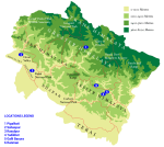
Six landscapes were identified in Uttarakhand for project implementation. Rasulpur and Shankarpur are located in the foothills of the Himalayas, while Ranman, Pipalkoti, Tadikhet, and Ranikhet lie within the Himalayan mountain region. The mountain system plays an important role in the climate of the region. Areas towards the north that fall within the rain shadow region have very little precipitation. Interior regions also have little rain, but are prone to landslides and flash floods during the winter monsoon season. Temperatures change vastly by altitude, but summers are usually extremely hot and winters cool. The higher areas of the Himalayas experience precipitation as snowfall from December to February.
Rajaji National Park is a protected forest located within the foothills of the Himalayas. Communities on the fringe of the National Park are sensitive to the needs of the landscape, but have become more reliant on cattle-grazing after being restricted from their previous dwelling areas in the forest. In addition to grazing, cultivatable land is used to grow cereals, pulses, sugarcane, and oil seeds.
Socio-economic Impact
Agriculture is the prevalent occupation of Uttarakhand’s over 10 million residents. Although still widely practiced, agriculture has become a subsistence activity that has limited benefits as an occupation. Agriculture is no longer economically viable as a sustainable source of income. As a result, segments of the workforce are seeking alternative employment at privately-owned small shops or factories in larger cities.
Alternative livelihood activities, such as factory jobs, have led to a decrease in sustainable land use stewardship. Increased occurrence of land fragmentation, weather changes, and market forces put additional pressure on remaining farmers to meet agricultural demand, which results in further land deterioration. Desertification makes the landscape more vulnerable to excessive erosion, which removes the thin topsoil layer and reduces soil fertility.
Managing the landscape has become an increasingly female task, as male household members migrate to other areas to earn a living. Land management adds an additional dimension to the many challenges that women face. Women are responsible for securing fodder for cattle, fuel wood for cooking, and water, which are all found far from the village. The involvement of women in the agricultural workforce is an essential aspect of food security in Uttarakhand.
Baseline Assessment
The COMDEKS baseline assessment was conducted in November 2012. The community consultation workshop included a SEPLS indicators piloting exercise, in order for stakeholders to measure the resilience of the target landscape. Community input at the workshop successfully informed the design of the COMDEKS Country Programme Landscape Strategy in India.
Field visits were conducted at eight different locations (at least 50-70 km apart from each other) within the state, so that community members could participate in the identification of increased pressures on natural resources and mountain communities. A system of cards and board based interactions engaged the community members in identifying appropriate resilience indicators for the socio-ecological production landscape. Community members also participated in a mapping exercise to validate the maps of participating villages. Main areas of concern included the loss of productive land due to forest fires, soil erosion, and threats from wild animals, soil and water degradation from industrialization, and a shortage of labor from migration. Poor market linkages and lack of awareness of best management practices have also contributed to the loss of biodiversity and the economic hardships that residents are facing.
Landscape Strategy
The overall long-term objective of the COMDEKS Landscape Strategy is to enhance socio-ecological production landscape resilience through community-based activities. The COMDEKS Country program in India seeks to achieve the following outcomes:
a) Enhancement of ecosystem services through conservation activities and sustainable use of natural resources
b) Improvement in agricultural productivity by promotion of sustainable agricultural practices, to increase food security and income generation
c) Promotion of alternative livelihood options, to enable access to markets and local financial institutions
d) Strengthening of institutional systems at the landscape level, through promotion of knowledge-sharing on natural resources management and landscape-related issues, and a more participatory decision-making process.
Country Project
The COMDEKS project seeks to bring about community development, learning, and knowledge sharing by making available small grants to community organizations to help them maintain and manage more resilient socio-ecological production landscapes. The types of community activities that will be supported by COMDEKS in the Uttarakhand region of India to achieve socio-ecological production landscape resilience will aim to promote sustainable management of natural resources. Water and soil conservation practices will minimize the threat of land degradation. Intercropping, the cultivation of mixed crops, maintains soil fertility and optimizes productivity through natural fertilization and pest reduction. Restoration of forested and grassland areas will help preserve the biodiversity of the region in the long-term.
There is potential for the balance between people and nature to be restored through pursuit of alternative livelihoods such as tourism, niche crops, handicrafts, health foods, organic produce, dairying, and floriculture, among others. Enterprise development, increased market access, and enhanced support for women will also contribute to improved food security and landscape resilience. Lastly, the COMDEKS project seeks to facilitate the formation of strong institutions for stakeholder involvement in landscape dynamics and management.
The COMDEKS Country Programme Landscape Strategy for India can be downloaded here


Project Contact
Mr. Prabhjot Sodhi
National Coordinator
Phone: +91-11- 26262878
Fax: +91-11- 26262880
Email: prabhjot.sodhi@ceeindia.org
Address
Centre for Environment Education, C-40, Ground Floor, South Extension – II , New Delhi 110049
